Methodological notes from the Sivas research and fieldwork. This study, which covers Sivas city and the modern province, is at the same time part of the Turkey Cultural Heritage research.
Sivas is the second largest province of present-day Turkey. Despite its vast 28,000 km2 span, the province is sparsely populated, with 300,000 people living in the provincial centre and another 300,000 distributed among the 17 districts. The vast span of Sivas brings with it the diversity and the geographical distances that create regions and subregions that do not necessarily overlap with the current administrative provincial borders. Over the decades since the establishment of the Turkish Republic, many changes were brought to the administrative structure of Sivas province, which is the successor to the Sivas vilayet. The vilayet that was established in 1867 covered the modern day provinces of Sivas, Tokat and Amasya as well as parts of Giresun, Erzincan and Kayseri provinces. In addition to the confusions created by the changing borders, the Armenian sources usually follow the administrative archdiocese system of the Armenian Patriarchate in Istanbul, which follows a mix of ancient divisions and modern adjustments.
The existence of different layers of cultural heritage in Sivas city is also applicable to the regions, with even more sophistication of regional and local influences. Sivas, Sevast, Siwas, Sebaste and other variations of the name come from the layered history of the area. A detailed timeline that shows the pivotal moments in the history of the region is part of this book (see p. 19). For the scope of this chapter, we should mention that it is important to differentiate between the cultural heritage sites that have been created or reused in these three different periods: early medieval, 10th-12th centuries, and 19th century. These three periods represent respectively the early Christian era of the city, the time when the Byzantine Empire transferred Armenians living in the outskirts of the empire to the central areas based on an agreement with the Armenian King Senekerim, and finally the industrial developments and population boom of the 19th century. This diversification brings a multiplicity of sources, which in turn brings discrepancies in the place and site names. Thus, different usages of those names in the Armenian and Ottoman sources, as well as the repetitive renaming of villages and settlements during the republican era, pose challenges for the compilation of the inventory.
Lacking the necessary minimum population to be included in the 5216 Law on Metropolitan Municipalities, Sivas has a central district that is composed of 68 neighborhoods and 153 villages. 36 sites are registered in 15 neighbourhoods and 26 sites in 12 villages. The availability of a map prepared by Arakel Badrig, author of the Sivas hushamadian (memory book), facilitated the process of identifying the cultural heritage sites or their original location in Sivas city. The otherwise extremely challenging process was reversed to a certain extent and 80% of the sites in Sivas city have been identified. It is important to mention that a guiding principle and an almost certain identifier is the location of a public building or a landmark in the place of each of the former cultural heritage sites. This is specifically true for the urban centers, where land is scarce and expensive. This scarcity has contributed to the destruction of cultural heritage sites in urban centers, while their survival is more probable in rural environments. The spolia of the churches are usually reused in the construction of other public buildings, mosques, police centers or schools, because of their reusable nature.
The last of the Sivas churches, Surp Asdvadzadzin Cathedral was demolished by explosives in the early 1950s during a wave of cultural heritage destruction that struck central Anatolian cities. In that regard, Sivas city has no standing Armenian church; the only one that can be considered to be close to the city is Surp Sarkis Church in the village of Tavra. It is inside a current military no-access zone; however, plans for its renovation are underway. For a long time there was a confusion about the naming of this church: it is mentioned as Surp Kevork in the official registry, though the sources indicate that Surp Sarkis is the correct name. Tavra, now modern day Paşabahçe, was once an Armenian village, and is today a favorite recreational destination. Many Republic-era Sivas Armenians can trace their origin back to Tavra. Oral history sources indicate that Tavra Armenians were exempt from the deportation thanks to their expertise in handling the flour mills that were positioned along the Tavra Stream. The only actively used Armenian cemetery is also in Tavra.
The nearby hills of Tavra, which are all currently occupied by military facilities, are home to Surp Anabad and Surp Hagop monasteries. We were not able to locate or analyze these monasteries due to their access status. Recently, the authorities began to give the Seljuk and Ottoman cultural heritage sites the attention they deserve. The same cannot be said with regards to the Christian cultural heritage sites in the city center. This is not only true for Armenian churches and monasteries, but also for world-renowned historic sites. The Forty Martyrs’ martyrdom and burial site of Saint Blaise (Surp Parsegh) are unidentifiable except with the guidance of the inhabitants of the city. In such situations, oral references are usually the only source of information and are treated as reliable enough to warrant registry in the inventory. As a result, most of the sites which were located on the basis of oral references were listed in the inventory despite the very limited information about their exact locations.
While locating churches in the urban centers has its challenges, locating them in the villages has its own characteristics. Our fieldwork experiences show that inhabitants in the villages remember only one church, although more than one may be listed in the inventory. Finding only one of the churches brings the problem of identifying which of the listed churches is the found one. In these cases, the most probable one was listed in the inventory with notes on the other churches listed in the same locality as possible entries for the located site. Another reality regarding the churches is that a multiplicity of cultural heritage sites are referred to as churches by the local population. These sites were not listed as churches in the inventory, except if there was a nearby church in the literature that was not located.
A characteristic of Sivas central district is its expansion to include many nearby villages. Hoghtar - modern day Höllüklük is a prime example; while it was then a small nearby village, today it can be considered a central neighbourhood.
Over the years, many villages from neighboring districts were administratively transferred to the central district. In the central district and beyond, many villages have been converted to ‘mezra’, an administrative unit that is connected to a nearby village yet forms a distinct group of households. As a result of a decrease in population and household numbers, former villages have either been merged administratively or reclassified. These changes have implications for the matching of the names between old and new and for the locating of sites. In several cases, the villages are transferred to a nearby location as a whole, which results in total loss of space memory.
The villages in the immediate proximity to the center are of particular cultural heritage value, because the cultural and economic life of the Sivas city extended to these locations. Famous Pirknik [Dörteylül] village - was the hometown of many renowned intellectuals, including poet Taniel Varujan, who was arrested on 24 April 1915 in Istanbul. Modern day Dörteylül also includes the Temeltepe plateau, home to the 5th Infantry Training Brigade campus, which includes the site of the now destroyed Surp Nshan Monastery, the most famous of Sivas monasteries, an 11th century complex and seat of the Sivas Archbishopate.
East of central Sivas are two large districts, Hafik and Zara, which together constitute a continuity of geography and cultural heritage of the city. Bedrosi and Koçgiri, by their old names, these two districts have 53 sites in 24 places registered in the inventory. Hafik is famous for a lake with the same name and Zara is the name of the mountain chain that separates the area from the northeast regions. The old road that goes from Sivas to Şebinkarahisar is the modern day highway that runs through Hafik and Zara, and lines up most of the villages. Hafik is also famous for being on the bird migration route, thus probably where the name Hafik - plural of the Armenian word for ‘bird’ originates. Numerous pigeon houses can be spotted in the region, located in close proximity to the monasteries. Pigeons were used by the locals for a multiplicity of purposes, ranging from food source to communication, and as grabbers of leftover wheat. The natural landscape has allowed for cave formations, which brings with it churches that were first established in caves, to be fortified later on and turned into built-up structures. Although further empirical studies are needed to establish a relationship between pigeon houses and cave-churches, our observations in the greater region extending between Sivas and Kayseri show a pattern.
The modern villages of Gövdün [Gökdin], Purapert [Günyamaç], Haght [Tuzhisar], Alişir, Kayadibi, Müslümabat [Alakilise] and Düzyayla [Horohon] have churches that still stand, which constitutes 30% of the churches listed under these two districts. A general but not exclusive style of the churches includes the use of wooden columns in the interior, many of which survive to this day, though some are missing their columns and roof. One major site that was not visited during the fieldwork is the Surp Hreşdagabed Monastery of Haght-Tuzhisar in Hafik. Being in a remote location up in the mountains, it is inaccessible by vehicles and a steep hiking route must be followed to reach it. Locals explained that the ruins of the monastery can be seen, however no built structures have survived. Sources indicate that Surp Hreşdagabed was considered among the monasteries that are close to Sivas city, and at a distance of six hours from it, probably by old village routes that are no longer in use today.
Both Zara and Hafik centres and many villages had sizeable Armenian populations during the 20th century. The majority of these have migrated to either Istanbul or outside of Turkey after the 1960s, as oral history sources indicate. The use and survival of the cultural heritage is thus conditioned by this major factor, a condition that can be generalized for all of Sivas. In regions where Armenians continued to live in the Republican period, Armenian cemeteries continued to be used by local Armenians. Several cemeteries survive to this day, at least on the administrative level, meaning that tombstones might have vanished but the property still belongs to the Cemeteries Directorate. The cemetery in the town of Hafik is one such example. Of the total 72 cemeteries in the inventory, 10 could be identified to follow this pattern. Although many Armenian cemeteries are used by the current locals as cemeteries, which makes them more problematic to identify as Armenian, in most cases they were either abandoned, or the property was divided for one part to be used for other purposes. Although the division causes a shrinking of the area, it also helps the preservation of at least one part of the site. In several cases, it was observed that the cemeteries were used for stones and soil for the village, or to fulfill the need for an open place for temporary storage.
It should be mentioned that cemeteries were observed to be the type of site listed in the inventory that are the easiest to spot and the most remembered. Nine cemeteries that were measured with either natural borders or surrounded by walls or fences totalled an area of 52,000 m2. Another factor that bounds the cemeteries is the fact that many of the collective burial places are remembered as cemeteries by the current locals. When asked about the village cemetery during the fieldwork, on several occasions areas were pointed out that were very remote, which makes them unlikely to have been the proper village cemetery. These were not listed in the inventory. Overall, cemeteries constitute 29% of the sites that were discovered during the fieldwork, the largest share after the churches, at 42%.
One village in Zara, Müslümabat-Alakilise, 33 km east of Zara town on the way to Suşehri, represents an important mix of cultural heritage sites, despite its modest representation in the literature. The church named Surp Minas that still stands on a cliff of Kızılırmak [Alis] was used for a long time as the mosque of the village until a new mosque was built, and the church is registered as a cultural heritage site. It was noted that this was a common practice and can be considered as an advantageous situation for the preservation of a church building. The buildings that were used as mosques were in a better condition than the churches that were used as warehouses or prisons. Another site in Müslümabat [Alakilise] is the Narekyan School, currently in use as the village hall; this is an extremely rare case of a school building still standing and especially being remembered as a school. This rarity comes from the facts that the schools and auxiliary buildings of the churches and monasteries were built with a simple architecture and the buildings were reused in forms that render their identification almost impossible.
Further to the northeast are the districts of Suşehri, Akıncılar, Koyulhisar and Gölova. Despite their many differences and specific characteristics they constitute a continuity in which the effects of the Black See region can be observed. We were able to spot 14 Greek villages, of which 8 were visited and a total of 11 sites were listed in the inventory. No doubt more research on the Greek cultural heritage, not only in the north but in the whole of Sivas, will change the image created in this study. The only source used for the identification of Greek cultural heritage in this study is the Ottoman Archives. A noteworthy site is the chapel that stands in Alişir-Meryemana Village (Village of Saint Mary) in Zara that continues to be visited today.
Suşehri-Akıncılar-Gölova, the area of Endires with its old name, was a part of the Şebinkarahisar district, which today is a part of Giresun province. The seat of Şebinkarahisar Archdiocese was the Garmrorag Surp Nshan Monastery, located in modern day Akıncılar. Only fragments of the monastery were located during the fieldwork. 26 villages are listed in the inventory of the total 134 in the three districts. 68 sites were listed in the inventory, of which 33 were located. One reality of the region are the reservoirs that were built over the last decades and covered many villages with artificial lakes. A general phenomenon of the Black Sea region, the construction of these reservoirs, dams and hydroelectric power plants meant that many of the buildings were submerged by artificial lakes or demolished by the authorities in order to facilitate navigation over the newly created lakes. This was the fate of several cultural heritage sites in the area, ruins of which lay exposed at certain times of the year when the water levels decrease.
An indirect effect of the reservoirs is ecological and weather change, the result of which is frequent landslides, which force the population to move their villages to safer areas. This movement leaves the original villages in neglect and increases the difficulty of access, resulting in the cultural heritage sites being more exposed to natural and human damage. The same danger results from population movement triggered by irrigation farming, road construction and other similar infrastructure changes. Other than the direct damage caused to cultural heritage, the structural changes in the landscape make the formerly accessible areas inaccessible. In certain cases, the sites were not visited for similar reasons and only oral references were relied on for the registration in the inventory. These include the cases in which the villages such as Bardizag [Bahçebaşı] in Hafik and Şemkürek [Esenyurt] in the center were reconstructed.
West of the centre is the region that is composed of the modern day districts of Yıldızeli, Şarkışla and Gemerek. This again is a region where Armenians continued to live up until very recently, and consequently many Sivas Armenians who live in Istanbul today can trace their ancestry back to the villages and towns in this region. Observations during the fieldwork indicate that fewer cultural heritage sites than other regions of Sivas have survived to this day despite the memory of the sites being vivid in most of the cases.
The characteristics of the village population is a decisive factor in the preservation of the memory of the cultural heritage in the area. Many of the villages have inhabitants that settled in the area after the departure of its previous inhabitants which results in a break in the memory chain, making it challenging to gather enough information for the inventory. The resettlements of populations from the Balkans and the Caucasus in Sivas have this effect to a great extent while settlements from other regions inside Turkey, especially from east and southeast of Turkey, result in a partial loss of the memory. On the other hand, the most vivid memories are kept in the villages that had mixed populations and whose current inhabitants had ancestors who had Armenian neighbors. This situation is even more advantageous when Armenian communities, or even a very few number of Armenians, continued to live in the villages or towns in the more recent past and passed their memories to the current inhabitants. As well as having the memory, the willingness to share the memory is also a factor. Property ownership and several other factors are hindrances for people to share the memory of the location or story of a cultural heritage. In a few cases the sites listed in the inventory were not able to be located due to either a lack of memory or a lack of willingness to share the memory. In several cases, sources expressed their unwillingness to share information about the sites due to a fear of restitution demands or legal actions that might endanger the ownership of their or their neighbors’ property.
The western districts are closer to Kayseri and many of the locals prefer commuting to Kayseri instead of central Sivas given the closer distances. Being more certain about this for Gemerek than for Yıldızeli, it shows the impact of the geographic distance of the modern day, and gives an idea about the belonging and cultural continuity in early 20th century and before. Even with modern day transportation, this reality still imposes itself as a determining factor to belonging. Of the 266 villages in the region in the three districts, 21 are part of the inventory, with 52 sites listed in them.
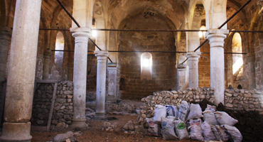
Gemerek, or Gamarag with its Armenian name, which means ‘small arch’, was home to a sizeable community that was settled in the Caucasus. A noteworthy town in the region is Çepni. Surp Sarkis Church of Çepni stands with its three naves, four walls, almost all of its columns, and the roof. Plans for rebuilding the municipality-owned site are underway, with Çepni’s compatriotic union in Germany being involved. This makes Surp Sarkis of Çepni a unique case of cultural heritage protection in Sivas.
Yıldızeli, Yenihan with its old name, today has a ‘Kilise Mahallesi’ [Church Neighborhood], but no structure that can be pointed to as a church, except a fountain that bears the same name as the neighbourhood. The Armenian cemetery is in the neighborhood and extends to 15,000 m2. A location close to Yıldızeli, called Tatarın Mevkisi [Tatar’s Locality], has a known site called ‘vank’ or ‘venk,’ meaning ‘monastery’ in Armenian. While Armenians who trace their ancestry back to Yıldızeli recount visits to this site as a yearly pilgrimage, modern day locals also mention the place as ‘manastır’. Regular visitation sites, natural formations of specific importance as well as old structures with no identifiable features are called ‘vank’ or ‘venk’. These cases were not listed as monasteries except if a known monastery from the literature was identified in the area. They are listed as chapels, a category now updated in the inventory to include the sacred pilgrimage sites, along with notes explaining the specific nature.
A word should be said on the importance and extent of the impact of the monasteries. Being centers of religion, education and communal life, monasteries also played decisive roles in the landowning and agricultural relations of the geographical area they were positioned in. As agents of collection, distribution and redistribution of wealth, monasteries were also intermediaries between the communities and the church hierarchy, thus also had a role in the communication, collection of information and its transmission across extensive regions. Analyzing the multiplicity of roles of the monasteries is beyond the scope of this study. Monasteries are mostly located remotely from the modern roads, which makes them hard to reach in many cases. As a result, 12 of the 21 monasteries were visited during the fieldwork. While two monasteries were not located, seven were not visited because either they were located inside military zones or were otherwise inaccessible.
South of the centre are the three districts of Ulaş, Kangal and Altınyayla. These three, and the area that extends northwards and is part of centre district, constitute the regions of Tonus and Kangal of historic Sivas. Tonus centre is modern day Altınyayla. 13 villages of the 173 in the area are part of the inventory and have a total of 38 sites listed between them. Churches in both Ulaş and Kangal centres were not standing, however both had cemeteries in their centres. The central mosque of Kangal, renovated in the 1990s had spolia used in its construction, coming from a monastic complex, Surp Toros, in the nearby town of Mancılık. This and similar cases of spolia reuse were noted in the inventory.
Ulaş, Kangal, and Mancılık, and many villages in the surrounding area had considerable Armenian populations after the founding of the republic. This population along with those in similar regions in Hafik and Zara have migrated to Istanbul or outside of Turkey starting in the 1940s. The migration still continues until this day affecting the number of Armenians still living in the urban or rural areas, one or two persons in a village in many cases. Deliberate destruction or negligence of the cultural heritage can be seen as a primary direct cause for this migration. The Armenians still living in the region constitute an important source of information on the sites, their use and reuse, and history of the cultural heritage sites listed in the inventory. Many Armenians of Sivas are members of the Association for Sivas Armenians and Friends and Zara Compatriotic Union, both based in Istanbul, and their assistance to this research throughout the fieldwork is of tremendous importance. Similar to central Sivas and Zara, Ulaş-Kangal area is also more connected to Sivas Armenians living in Istanbul than the other regions of the province. This connection is alive through Armenian families returning in the summer to their villages and a few even having elderly members remaining in the home villages.
The southernmost district is Gürün, which neighbors Malatya and Kahramanmaraş provinces. Significant differences in the geographic and cultural landscape can be noticed between northern and southern Sivas. Out of the 65 villages of Gürün, six are part of the inventory and 25 sites are listed in them. The Tohma stream runs through the centre of Gürün and forms a valley with the same name, extending downstream to Malatya. Tohma or Tokhmakhsu with its old name, eventually unites with the Euphrates in the Karakaya Reservoir. Several settlements around Gürün are formed alongside Tohma, with Şuğul to the west of Gürün centre and Suçatı to the east.
Central Gürün has a standing church, Surp Asdvadzadzin, in its centre. Although the roof and the columns have collapsed, many of the walls, three apses and several other features are still intact. The building was used as a prison and a cinema and finally a warehouse over the course of the 20th century, until it was recently registered as a cultural heritage site and taken under protection. Plans for restoration by Gürün Municipality are underway. During fieldwork, we were not able to spot many of the inventory sites listed in Gürün. Orphanages, schools, Protestant and Catholic sites could not be identified due to urbanization in central Gürün.
Many Gürün Armenians lived as a community in refugee-settler camps in Aleppo. Many Aleppo and Diaspora Armenians trace their ancestry back to Gürün. This also creates a different trace from the rest of Sivas. Gürün Armenians share the destiny of Cilicia Armenians, similar to that of Maraş, Antep, Kilis, Adana, and Urfa, meaning that they were displaced towards Syria while the rest of Sivas continued to have sizeable Armenian communities, similar to other parts of Central Anatolia.
Towards the southeast of Sivas is the district of Divriği, Divrig or Tefrike by its old names. A remote district, Divriği is an hour drive from Kangal towards the east and is over the rail line that runs through Sivas, Ulaş and Kangal and exits Sivas to Erzincan in Divriği itself. Many of the villages in Divriği are part of the geography that includes the Kemaliye and İliç districts of Erzincan. Geography, economy or culture of the area cannot be understood without taking into account both sides of the Sivas-Erzincan border. Pingen [Adatepe], Gasma [Kesme] in Divriği and Zımara [Altıntaş] in Erzincan form the area that constituted the bulk of the economy and culture of the area at the turn of 20th century, with each of the three villages having on average a population of 1500 while the modern day Divriği district has a population of 14,000 in 2017 (down from 17,000 in 2007) counted in the central town and the 108 villages of the district. 18 villages are registered in the inventory with 55 sites listed in them.
Divriği is famous for the Ulu Cami and Hospital complex, a UNESCO World Heritage Site, and for its fortress, a stronghold of the Paulicianism movement. Less is known about the numerous Armenian monasteries and other cultural heritage scattered in the mountainous areas surrounding Divriği. A noteworthy site in Divriği that is even less known is the site of the burial of Krikor Naregatsi, a medieval monk and a saint of the Armenian Apostolic Church and the Catholic Church. Duruköy, or Arege with its old name, is a village on the border between Sivas and Erzincan and is mentioned by Srvantsdyants to be the burial site of Naregatsi. The modern day village has an Islamic shrine with the name of Pir Shanmaz/Shammas. Many Armenian spiritual sites are accepted as sacred by the local Muslim population in Divriği, especially by the Alevi population. Another interesting example is the site of Surp Hagop Monastery that is now visited as Kara Yakup Baba Shrine, where also candles are lit. These sites were recorded in the inventory with their original function and their current use noted down. The reuse of cultural heritage of this nature does not only contribute to the preservation and survival of the sites, but also provides a venue of dialogue and communication between different communities that regard the same sites as sacred.
Finally, treasure hunting should be mentioned as a major factor of cultural heritage destruction in the region. Both locals and outsiders to the regions practice treasure hunting regularly despite measures taken by the security authorities and the registration of the sites. Registration per se is an important step towards criminalization of the destructive activities, yet mere registration remains short of any tangible effect on the destruction process. Economic factors are cited by the locals as a major reason that treasure hunters pursue valuables in cultural heritage sites. This said, it should be noted that practitioners of the treasure hunting have a grasp of the cultural heritage sites and possess extensive knowledge of the landscape and geography of the area, and in several cases, information provided by them was noted in the inventory.
- For the administration and status of the Armenian church, see Maghakia Ormanian, Hayots Yegeghetsin [Armenian Church], 2. edition (Yerevan: Parberakan, 1993), pp. 153-168
- “5216 Sayılı Büyükşehir Belediyesi Kanunu” [5216 Law on Metropolitan Municipalties], Resmî Gazete, no. 25531, 23 July 2004
- Arakel Badrig, Badmakirk Hushamadyan Sepasdio yev Kavari Hayutyan [History of the Armenians of Sepastia and Neighboring Villages], vol. 1 (Beirut: Meshag Press, 1974), p. 625 (621-631)
- See the Tavra Village and Surp Sarkis Church chapter of this book
- Hamazasb Voskian, Sepasdiayi Vankerı [Monasteries of Sivas] (Vienna: Mkhitaryan, 1946), p. 15
- Oral history interview, HDF20342003600 and HDF203310073800 (Hrant Dink Foundation Archives, HDF)
- For Greeks living in the region, see İhsan Tevfik, “Mübadelede Sivas’tan Rumların Göçü” [Immigration of Greeks from Sivas during the Population Exchange], Hayat Ağacı 22 (2013): 61-69
- Gonca Büyükmıhçı, Hale Kozlu, Ayşegül Kılıç and Sevde Karahan, “Çepni Surp Sarkis Ermeni Kilisesi Restorasyon Çalışmaları” [Restoration Works of Surp Sarkis Armenian Church in Chepni], Erciyes Üniversitesi Sosyal Bilimler Enstitüsü Dergisi 1, no. 39 (2015): 42-66
- One aspect of this issue, which is the relationship between the monasteries and agriculture, is explored in chapter Indigenous Production Landscapes of Divriği of this book about Kesme village. The findings of the research carried out by the Doğa Derneği during the Sivas fieldwork was summarized
- Talin Suciyan, The Armenians in Modern Turkey (London: I.B. Tauris, 2015), p. 59
- Karekin Srvantsdyants, Toros Aghpar Hayasdani Camport [Toros Aghpar Traveller of Armenia], vol. 1 (Istanbul: Dndesian, 1879), p. 213.